
Kennesaw Mountain National Battlefield Park
Kennesaw, Georgia
- Volunteer forms = Adult / Minor(17 and younger)
- / Update 3/30/2024
- .

Maps & Hiking Tips
This section contains the various maps of the park and the hiking trails. We have both topo maps
and regular maps in PDF form that you can use to print your own maps for use in hiking the trails.
We will be expanding this section to add more information including various trail distance tables
and describe various loop trails.
Below is a list of maps that will open in another browser tab.
We are adding more detailed hiking maps, here are 3 new maps that show more detail divided by the three destinct sections that the park is divided into
Southern Trail Section
Central Trail Section
Northern Trail Section
Official NPS park map
Kennesaw Mountain Trail Club map
The NPS KEMO website includes an interactive of the Park. When you drilldown, you will see the 24 Gun and Environmental Trails
Interactive park map
PDF use to print a copy
Map from KEMO Brochure
On the home page are links to the videos for the Emergency Location Markers in the park.
Cobb County is putting up Emergency Location Markers on hundreds of miles of trails across the county. These markers will give trail users the ability to tell dispatchers exactly where they are if they need help. A free iphone app called MyUSNG can be used. MyUSNG reports the location of your device in US National Grid format (USNG). With a single tap on the screen, you will copy the USNG location into your clipboard. With a tap and hold, you can easily e-mail your USNG location. It will even show a topo map. Google Play store provides the same app for Android.
The three maps that were in this section have been removed to comply with NPS standards.
The park has contacted with the NPS GIS team and the NPS GIS team is going to make new visitor maps for the park. What we expect is a much better quality map as a result. It is our understanding that the Visitor center will not be handing out maps until they get the new ones.
Blank Trail Report You can print a copy of this, use it to report trail issues.
Trail Distance in miles |
||||
East Trail |
West Trail |
|||
| Trail Name |
Length |
Trail Rating |
Length |
Trail Rating |
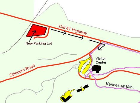
| Visitor Center to Mountain Top |
1.0 |
Moderate - Strenuous |
||
| Visitor Center to Burnt Hickory Road |
2.7 |
Easy - Moderate |
2.8 |
Moderate - Strenuous |
| Burnt Hickory to Dallas Hwy. |
1.5 |
Easy - Moderate |
2.2 |
Easy - Moderate |
| Dallas Hwy to Cheatham Hill lot |
0.7 |
Easy - Moderate |
0.7 |
Easy - Moderate |
| Cheatham Hill to Kolb Farm |
2.5 |
Easy - Moderate |
2.8 |
Easy - Moderate |
| 24 Gun Trail |
1.135 |
Easy - Moderate |
||
Loop Trails (using both East & West trails) |
|
| Vistor Center to Mountain Top | 2.0 |
| Vistor Center to Pigeon Hill | 5.4 |
| Visitor Center to Cheatham Hill | 10.2 |
| Visitor Center to Kolb Farm | 16.2 |
| Burnt Hickory to Dallas Hwy | 3.7 |
| Cheatham Hill to Kolb Farm | 5.5 |
Official list of trail names and trail locations
| Trail Name | Trail Location |
|---|---|
| Environmental Trail | Off of the Visitor Center Picnic Area |
| Kennesaw Mountain Trail | Visitor Center over Mountain top to Kennesaw Mountain Dr. |
| Rifle Pit Trail | Visitor Center to fire road (left side of Kennesaw Mtn Trail) |
| Little Kennesaw Mountain Trail | Off of Kennesaw Mountain Dr. to Little Kennesaw Mountain to Camp Brumby Trail; connects north of Pigeon Hill |
| French's Rock | South of Little Kennesaw Mountain |
| Pigeon Hill Trail | Little Kennesaw Mountain Trail to the Burnt Hickory Rd./Old Mountain Intersection |
| Pigeon Hill Cut-off | Pigeon Hill Trail to Camp Brumby Trail, south of Pigeon Hill |
| Visitor Center Cut-off | Behind the Visitor Center to Camp Brumby Cut-off |
| Camp Brumby Cut-off Link | Kennesaw Mountain Trail to Camp Brumby Trail Camp Brumby Trail to Kennesaw Ave. |
| Camp Brumby Loop | Circles the Camp Brumby ruins |
| Camp Brumby Trail | Camp Brumby Cut-off to Burnt Hickory Rd.; formally the East or Base Trail |
| Noses Creek Trail | Burnt Hickory Rd. Parking Lot south to the Noses Creek Bridge |
| New Salem Church Trail | South of Burnt Hickory Rd. to Noses Creek Trail |
| Hardage Mill Trail | Noses Creek Trail, north of intersection with New Salem Church Trail to Whitlock Ave. |
| Noses Creek Service Road | Southeast of the Noses Creek Bridge |
| Cease Fire Trail | Whitlock Ave. at Cheatham Hill Dr. entrance to Kolb's farm Connector |
| Old John Ward Road Trail | Dallas Highway south to Cheatham Hill Rd. Parking Lot |
| Old John Ward Connector | Cease Fire Trail to Old John Ward Trail |
| Monument Trail | Cheatham Hill Parking Lot to the Illinois Monument |
| Unknown Soldier Trail | Behind the Illinois Monument to Kolb's Farm Connector |
| Kolb's Farm East Trail | Cheatham Hill Rd./Powder Springs Rd. Intersection to Cheatham Hill Parking Lot |
| Kolb's Farm Connector | Cheatham Hill Rd. Parking Lot to the Kolb's Farm East Trail; crossing Activity Field #3 |
| Kolb's Farm West Trail | Cheatham Hill Rd. Parking Lot to Cheatham Hill Rd./Powder Springs Rd. Intersection |
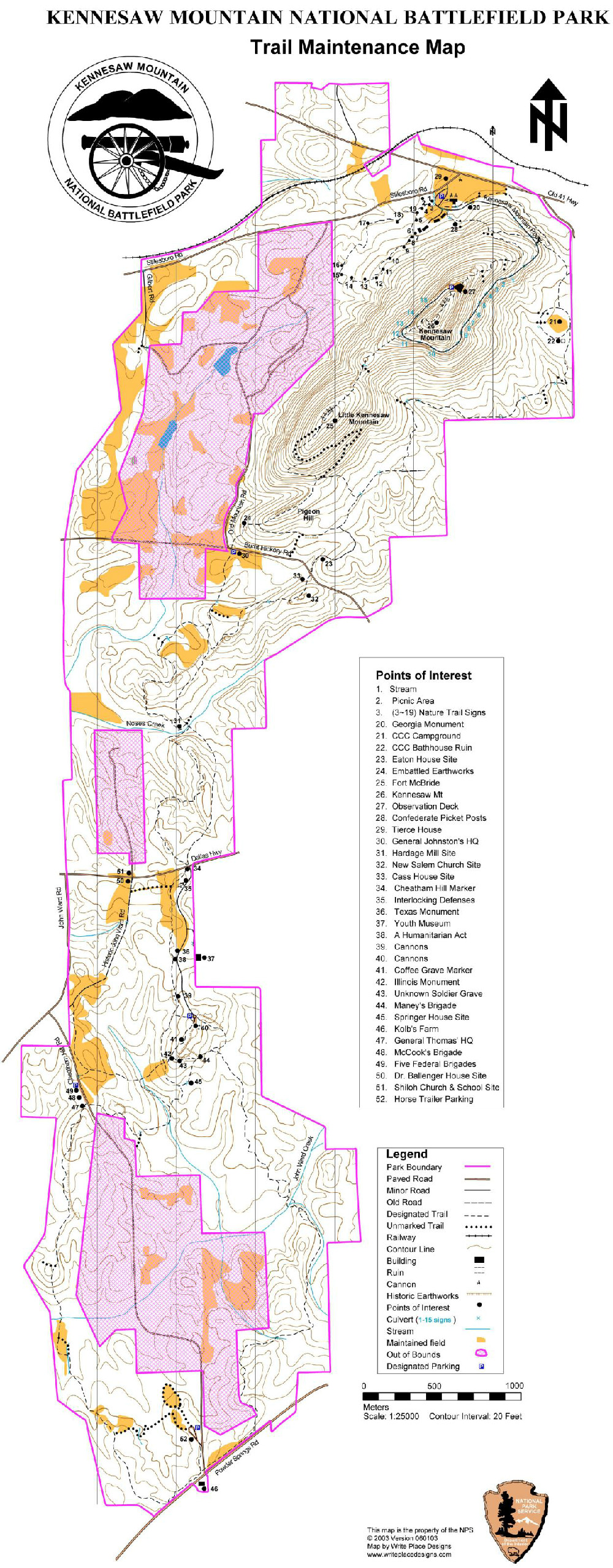
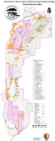 Full Park Full Parkclick map to open in new tab or download file |
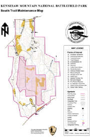 Southern End Southern Endclick map to open in new tab or download file |
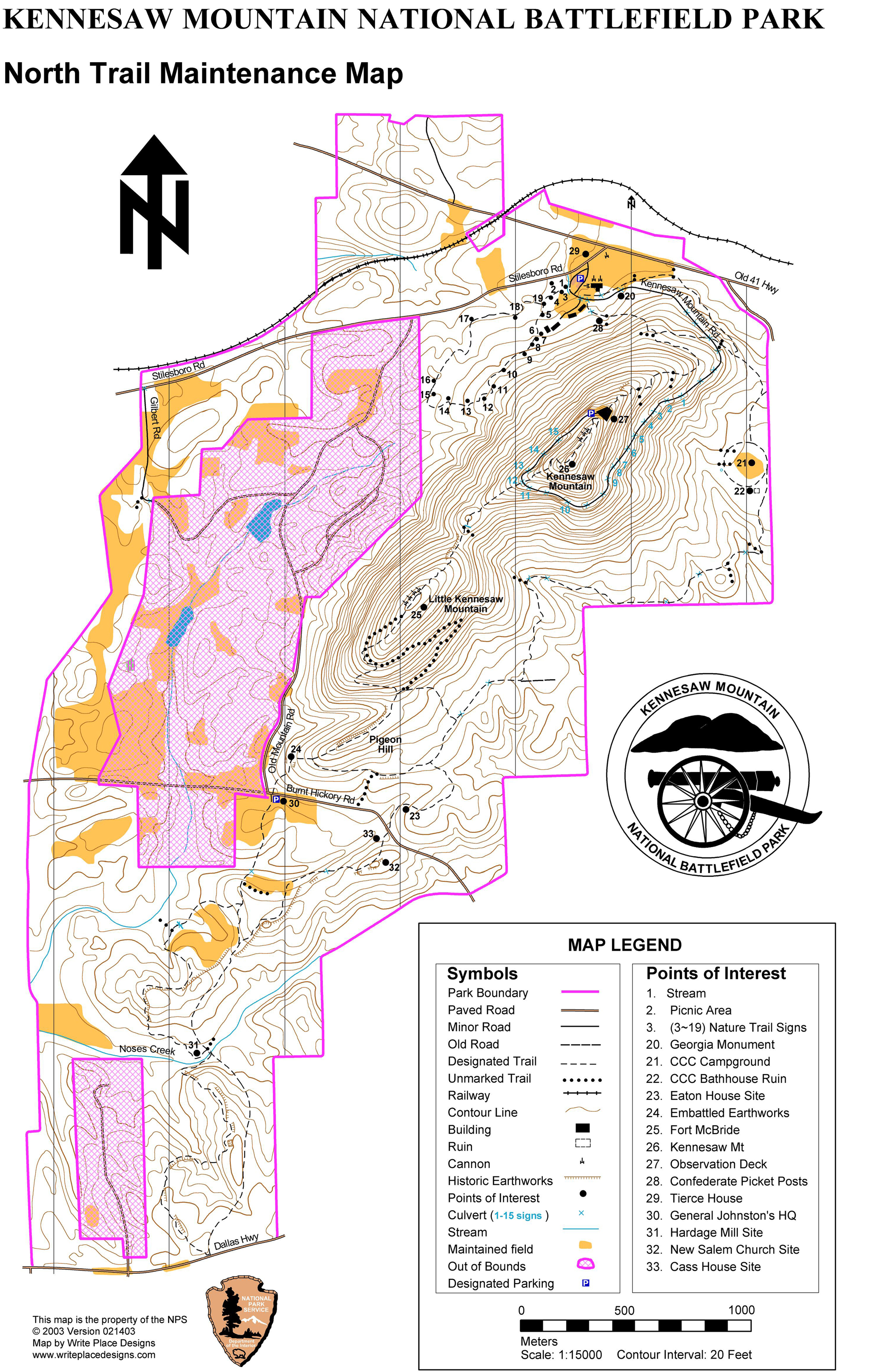
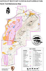 Nothern End Nothern Endclick map to open in new tab or download file |
 |
||
.